Native Angeleno who has worked in public, academic and special libraries, as well as museums and college instruction. I am responsible for maintaining the Metro Transportation Library website, all of our social media properties, and digitization efforts to bring more of our resources to our users whenever they need them. For more information, visit The Metro Library website.

Monday, November 29, 2010

New And Notable: Los Angeles From The Air Then And Now, Makeshift Metropolis & Down The Asphalt Path

Avid readers of local history are usually intrigued by photos of historic sites juxtaposed against contemporary images. This format of visual history has a particularly strong impact when the subject is Los Angeles: a city that grew up -- and outward -- so quickly.

Those seeking pictorial overviews will likely have checked out aerial photography books as well.

Los Angeles From The Air: Then And Now (San Diego: Thunder Bay Press, 2010) is a hybrid of these two types of pictorial books. It presents decades-old photographs of both familiar and lesser-known landmarks along side more current ones.

This takes the reader on a trip through Los Angeles like never before, featuring inspiring, sky-high then-and-now images of some of LA's most famous locations.

Some of the landmarks' origins are well-known, but the authors provide context for both familiar and hidden pieces of Los Angeles history.

Many of the photos feature snow-capped peaks in the distance -- a testament to our clear Winter days being the best for photography.

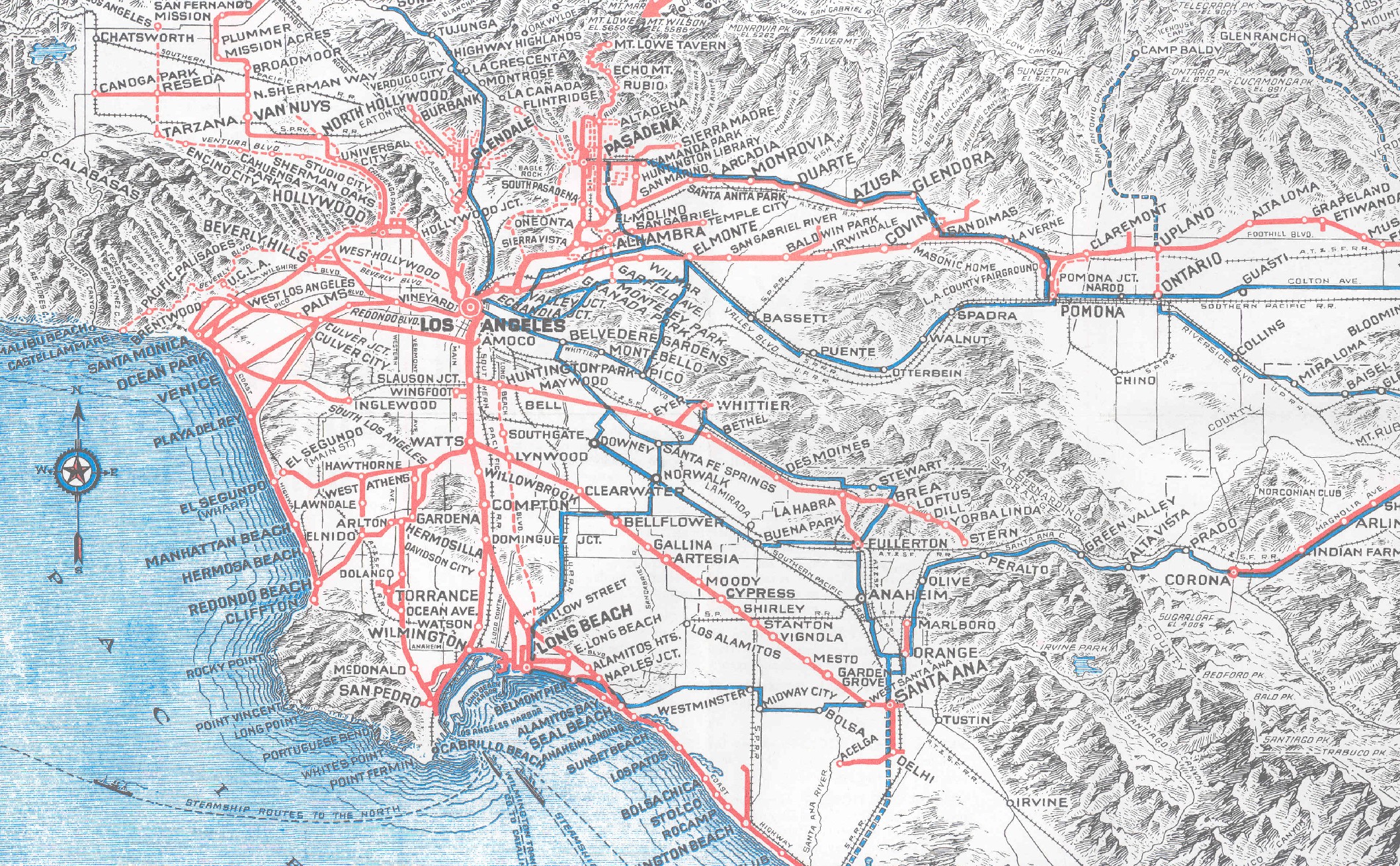
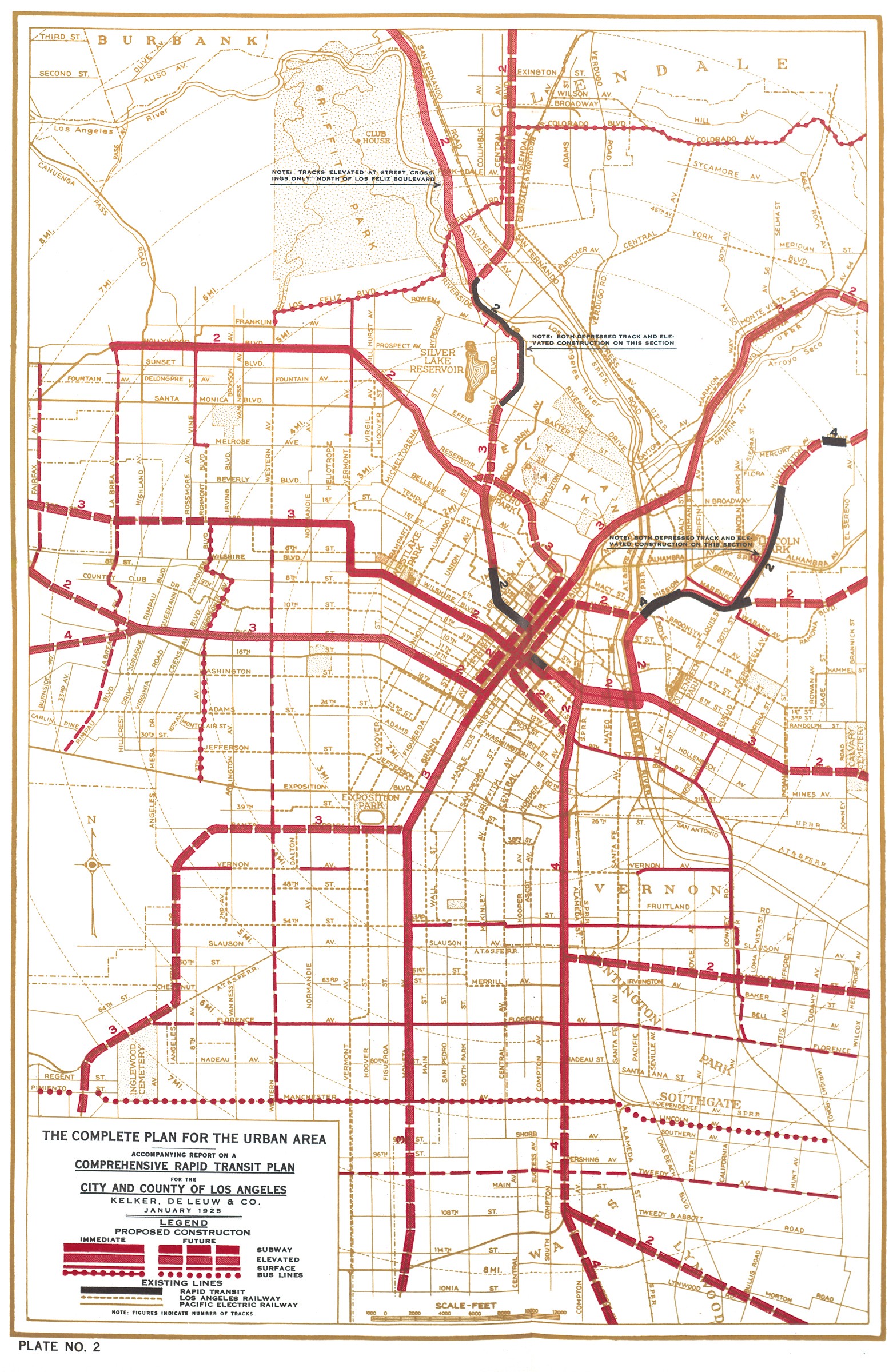
Unfortunately, the work falls flat in its description of transportation in downtown Los Angeles. The authors write:

"Metrolink [sic] provides service to Union Station in the form of three rail lines -- Red, Purple, Gold..."

While Metro and Metrolink may sound similar to those outside of Los Angeles (the book is, after all, published in San Diego), it gives one pause that other information found here may not be entirely accurate. Ultimately, one can ignore the text entirely, as these beautiful photos speak for themselves.

In Makeshift Metropolis: Ideas About Cities (New York: Scribner, 2010), noted architecture writer Witold Rybczynski offers a glimpse of an urban future that might very well serve as a template for cities around the world.

Rybczynski integrates history and prediction of the development of the American city in a brisk look back that takes us from colonial town planning to the Garden City and City Beautiful initiatives of the early 20th century and on to the "Big Box Era."

He also examines how contemporary urban designers and planners are revisiting and refreshing older urban ideas, such as bringing gardens to a blighted Brooklyn waterfront.

Rybczynski's study is kept relevant by his focus on what the past can teach us about creating the "cities we want" and "cities we need."

The prose is instructive and always engaging, and the author's enthusiasm for the future of cities and his enduring love of urban settings of all kinds is evident.

He not only writes about what people want from their cities, he inspires the reader to imagine the possibilities.

In Down The Asphalt Path: The Automobile And The American City, author Clay McShane examines the uniquely American relationship between "automobility" and urbanization.

Writing at the cutting edge of urban and technological history, he depicts how new technology, namely the private automobile, and the modernization of the American city redefined each other.

The author motors us across the country -- from Boston to New York, from Milwaukee to Los Angeles and the suburbs in between -- chronicling the urban embrace of the automobile.

The New York Times calls this work "A treat to read, loaded with interesting facts...a notable book about urban transportation."

Barron's wrote that "this fascinating, well-researched history of the automobile industry...is written from a social and cultural perspective rarely included in traditional books about the business."

The Whole Earth Review claims "this fascinating treatise is the most credible look yet at how automobiles have changed American society for better or worse."

Tuesday, November 23, 2010

New And Notable: Sprawl Repair Manual, Republic Of Drivers & Urban Mass Transit's Life Story

There is a wealth of research and literature explaining suburban sprawl and the urgent need to retrofit suburbia. However, until now there has been no single guide that directly explains how to repair typical sprawl elements.


Sprawl Repair Manual demonstrates a step-by-step design process for the re-balancing and re-urbanization of suburbia into more sustainable, economical, energy- and resource-efficient patterns, from the region and the community to the block and the individual building. (Even more information can be found at the Sprawl Repair Manual website).


Author Galina Tachieva asserts in this exceptionally useful (and exceptionaly handsome) book that sprawl repair will require a proactive and aggressive approach, focused on design, regulation and incentives.


The work provides much-needed, single-volume reference for fixing sprawl, incorporating changes into the regulatory system, and implementing repairs through incentives and permitting strategies. It draws on more than two decades of practical experience in the field of repairing and building communities to analyze the current pattern of sprawl development, disassemble it into its elemental components, and present a process for transforming them into human-scale, sustainable elements.


The techniques are illustrated both two- and three-dimensionally, providing users with clear methodologies for the sprawl repair interventions, some of which are radical, but all of which will produce positive results.


Rising gas prices, sprawl and congestion, global warming, even obesity—driving is a factor in many of the most contentious issues of our time. So how did we get here? How did automobile use become so vital to the identity of Americans?


Republic Of Drivers: A Cultural History Of Automobility In America looks back at the period between 1895 and 1961—from the founding of the first automobile factory in America to the creation of the Interstate Highway System—to find out how driving evolved into a crucial symbol of freedom and agency.


Author Cotten Seiler combs through a vast number of historical, social scientific, philosophical, and literary sources to illustrate the importance of driving to modern American conceptions of the self and the social and political order.


He finds that as the figure of the driver blurred into the figure of the citizen, automobility became a powerful resource for women, African Americans, and others seeking entry into the public sphere.


And yet, he argues, the individualistic but anonymous act of driving has also monopolized our thinking about freedom and democracy, discouraging the crafting of a more sustainable way of life.


As our fantasies of the open road turn into fears of a looming energy crisis, Seiler shows us just how we ended up a republic of drivers—and where we might be headed.


In Urban Mass Transit: The Life Story Of A Technology, the history of mass transit is vividly illustrated as the technological and social struggles that have accompanied urbanization and the need for an efficient and cost-effective means of transportation in cities.


From the omnibus and horsecar in the 1830s to the renaissance of urban mass transit at the turn of the 21st century, author Robert C. Post depicts mass transit as a technological system that provided an essential complement to industrialization, urbanization and, ultimately, to the rise of consumer culture.


At the heart of the story is the streetcar, a conveyance that played a central role in the development of U.S. cities and towns. Once dominating the urban landscape, the streetcar has all but disappeared. Post traces its evolution and demise, debunking the urban myth that the downfall of the electric streetcar was directly attributable to the corporate malfeasance of General Motors and others from the automotive world.


Post concludes with a meditation on the prospects for mass transit in a postmodern society that must face up to the contradictions of privatized mobility and the reality of dwindling natural resources.


Monday, November 22, 2010

Digitization And Transportation: Northwestern University's Google Books Project

Beginning today, Northwestern University's Transportation Library begins its Google Books Digitization Project.

The University Libraries and Google are partnering to digitize hundreds of thousands of print volumes from their collections, rendering the contents readily available to scholars and researchers worldwide.

This is no small undertaking. The Transportation Library alone is one of the most extensive in the United States, containing over 500,000 items.

The Committee on Institutional Cooperation, a consortium of the Midwest's Big Ten Schools' plus the University of Chicago, signed on to digitize their libraries in June, 2007 but the process is just getting underway this Fall.

The project is expected to take several years, but the Transportation Library is one of the first campus libraries to send library items to Google for digitization. Google covers the transportation and digitization costs and Northwestern has received a generous donation from the Office of the Provost to help cover other technical costs.

We are told that books sent to Google for digitization may be off the shelves for up to three months. Once everything eligible for converting into electronic format has been digitized, those searching the library catalog will have the choice of borrowing the original print item or accessing the full-text document online.

Results from Google Book Search show up in both general Google searches as well as through the dedicated Google Books site.

The entire Google Books project has been a source of controversy over the last decade. Some hail the initiative's capacity to provide "anytime, anywhere" access to all of human knowledge. Others question the application of copyright laws for works published in one place but accessed around the world.

The Google Books enterprise is a complicated endeavor. While access to the ever-increasing (and increasingly digitized) world of knowledge is great, how can Google maintain a high-level of retrievability from a growing pool of millions of items? A recent article in The Atlantic highlights this challenge, with a concise overview of "Rich Results," Google's latest search algorithm that helps users find what they're looking for...even when they don't specifically ask for it.

Last month, Google speculated that it had scanned more than 15 million books from more than 100 countries in over 400 languages since 2004. Google Books' Engineering Director James Crawford went on to state:

"Our shared vision of bringing all the incredible content stored in the world's books online depends on working with libraries, publishers, authors and book lovers.

The greater the diversity of content on the web, the more useful it becomes. And the more people who can access the information cataloged in books, the more enlightening those works become."

Our goals are the same. Here at Metro's Dorothy Peyton Gray Transportation Library & Archive, we have embarked on a digitization project of our own (sans Google) as outlined here. We want to provide greater access to our rich collections, make items more easily findable and retrievable, and preserve information and knowledge for generations to come.

Thursday, November 18, 2010

Los Angeles In Maps & The Curious Case Of Miss Laura J. Whitlock

One the most exciting new books in a long time has been released this month: Glen Creason's Los Angeles In Maps (New York: Rizzoli, 2010).

Creason is the Map Libraran at Los Angeles Public Library and co-curated the landmark 2008-2009 exhibition L.A. Unfolded: Maps From The Los Angeles Public Library.

This new work guides the reader through the variety of maps created for Los Angeles, from the 1849 Plan De La Ciudad De Los Angeles ("Ord's Survey") to modern day interactive maps.

The book works on a number of levels: as history lesson, as a beautiful coffee table book with intriguing graphics, as a thought-provoking work showing how spatial depictions have changed over the past century and a half, and how Los Angeles can be viewed in historical context in ways other than chronological.

It is organized into chapters that tell the various stories of Los Angeles, such as Early Growth, Social Life, Water, Age of the Automobile, Tourism, etc.

Fortunately for us, there is a Transportation section, where we learn the story of Laura J. Whitlock, official mapmaker of Los Angeles County - and the only female map publisher in the United States when she was working in the early 20th century.

Pirated copies of her work were widely distributed without her consent, and she filed suit for copyright infringement. We'll leave it to you to discover what happened with this landmark case, but it did set a precedent for map copyright -- an important contribution to American map history made here in Los Angeles.

The rest of the transportation maps and information are equally interesting, as are the other subject areas covered, but you'll have to read the book yourself to find out more.

It suffices to say that the highly-readable nature of Los Angeles In Maps makes it an instant classic for those interested not just in maps, but the history and growth of the city as well.

We had hoped to find the same maps featured in the book on the Los Angeles Public Library website. Unfortunately, the L.A. Unfolded exhibit is not listed on the LAPL Past Exhibits webpage, but some of their 100,000 maps can be found in their digital collection online.

We, however, maintain an online map collection titled Past Visions Of L.A.'s Transportation Future: Mass Rapid Transit Concept Maps.

Here you will find an online gallery from 1925 to present-day, focusing on proposed rail and rapid transit plans over the years.

We are hoping to bring more map resources online as time permits.

(Above: 1925 Pacific Electric Route Map, click to enlarge. These old maps are full of intriguing tidbits, like Sunset Boulevard being the original Beverly Boulevard - as noted here).

Readers are also invited to explore our full-text digital collection of Los Angeles Transit And Transportation Studies, 1911-1957. These documents also include rare maps and other illustrative material from L.A.'s transit and transportation history.

Tuesday, November 16, 2010

Light Rail On Wilshire? Why, That Would Be Illegal!

The recent selection of a route alignment for the Westside Subway Extension, as well as the release of the Wilshire Boulevard Bus Rapid Transit final environmental impact report started us thinking about something we read aways back regarding Wilshire Boulevard.

It was in Kevin Roderick's Wilshire Boulevard: Grand Concourse Of Los Angeles (Santa Monica: Angel City Press, 2005). The author briefly mentions (on page 20):

"New subdivisions around the periphery of Los Angeles were not unusual in the mid-1890s, but the Wilshires had grander ambitions. Across the center of their land, they promised to grade a generous, one-hundred-twenty-foot-wide graveled boulevard.

It would stretch just four blocks between the two parks, but the brothers believed that even a short stub of remarkable avenue would attract lot buyers.

To spur sales, they lobbied to encircle the tract with special streetcar lines, but insisted that the city council forbid the laying of tracks - forever - on their boulevard."

Forbid the laying of tracks?

Forever?

Really?

We had to determine if this had actually been codified, and turned to the City of Los Angeles Municipal Code to investigate.

Sure enough, we discovered in SEC. 62.129. PUBLIC BOULEVARDS - USE OF:

That the following regulations shall apply to those certain streets in this City, known as Wilshire Boulevard, from Park View Avenue to the west City limits; Adams Street from Grand Avenue to Hoover Street; Boyle Avenue from Whittier Boulevard to First Street; Alvarado Street from Seventh Street to Hoover Street; and Occidental Boulevard from First Street to Sixth Street; which have been heretofore dedicated as open, public boulevards:

(a) No railroad or pipe line franchise shall ever be granted, and no railroad track or pipe line shall ever be laid or constructed, except water pipes, sewers, gas mains and conduits for telephone and electric wires, for service of the property fronting on said boulevards and house connections and connections of water, sewers, and gas pipe lines, or conduits for telephone and electric wires on intersecting streets.

The early developers of Wilshire were successful in banishing rail lines from the Boulevard forever. Despite having the greatest urban rail system in the world in its heyday, no streetcars ever rumbled down Los Angeles' grandest street.

This 1925 Kelker DeLeuw City/County Comprehensive Rapid Transit Plan Urban Map shows nothing on Wilshire - cross-town streetcars were designated for Pico Boulevard, 3rd Street, and Hollywood Boulevard.

A 1938 Los Angeles Railway map depicts cross-town streetcars on several east-west lines: 3rd Street (R), 10th Street / Olympic Boulevard (L), Pico "Street" (P), Washington Boulevard (W), and Jefferson Boulevard (J). Only motor coaches served Wilshire Boulevard.

Wilshire still became the city's grandest boulevard despite its lack of "rapid transit" - or perhaps because of it - and Rodericks' book is a fascinating account of Los Angeles' iconic boulevard and how one street can influence such a large city.

We can't know how the street or city would have developed had streetcars run along it, but Wilshire Boulevard never got stuck with overhead transit either.

We might be thankful we didn't end up with a Wilshire monorail, as one proposal depicted the intersection of Wilshire & Fairfax here.

Meanwhile, this Saturday marks the annual Great Los Angeles Walk, which goes back to its roots this year.

The day-long trek will take participants 15.6 miles along the entire length of Wilshire Boulevard, from Pershing Square downtown to its west end at the Pacific Ocean in Santa Monica.

The L.A. Conservancy has a wonderful interactive website that helps visitors create their own customized tours of Wilshire Boulevard's past and present.


Monday, November 8, 2010

New & Notable: America's Failing Infrastructure, "Climatopolis," & Why Do Shepherds Need A Bush?

In August 2007, the I-35W Bridge in Minneapolis, MN, collapsed, killing 13 and injuring 145 others. Investigations following the tragedy revealed that it could have been prevented. The grave reality is that it is a tragedy that threatens to be repeated at many of the thousands of bridges located across the nation.

In Too Big To Fall: America's Failing Infrastructure And The Way Forward (New York: Foster, 2010), author Barry LePatner chronicles the problems that led to the I-35W catastrophe — poor bridge design,shoddy maintenance, ignored expert repair recommendations, and misallocated funding — and digs through the National Transportation Safety Board’s report on the tragedy, which failed to present the full story.

From there LePatner evaluates what the I-35W Bridge collapse means for the country as a whole — outlining the possibility of a nationwide infrastructure breakdown.

He exposes government failure on a national as well as state level, explains why we must maintain an effective infrastructure system — including how it plays a central role in supporting both our nation’s economic strength and our national security — and rounds out the book by providing his own well-researched solutions.

Too Big to Fall presents an eye-opening critique of a bureaucratic system that has allowed political best interests to trump those of the American people. It contains special comments by James Oberstar, the outgoing Chairman of the U.S. House Committee on Transportation & Infrastructure.

Cities are the engines of the economic growth and the foundation of our prosperity. But what will become of them as our world gets hotter?

In Climatopolis: How Our Cities Will Thrive In The Hotter Future (New York: Basic, 2010), Matthew Kahn, one of the world's foremost experts on the economics of the environment and of cities, argues that our future lies in our ability to adapt. Cities and regions will slowly transform as we change our behaviors and our surroundings in response to the changing climate. Kahn - professor at the UCLA Institute of the Environment and Sustainability, the UCLA School of Public Affairs' Department of Public Policy, and a research associate at the National Bureau of Economic Research - shows us how this will happen.

The author is optimistic about the quality of our lives in the cities of the future, despite a high chance of less hospitable climate conditions than we face today. At the heart of his conviction in a bright future is our individual freedom of choice. This personal freedom will reveal pathways that will greatly help urbanites cope with climate change.

Taking the reader on a tour of the world's cities - from New York to Los Angeles, Beijing to Mumbai - Kahn's clear-eyed, engaging, and optomistic messages presents a positive yet realistic picture of what our urban future will look like.

An entire chapter is devoted to Los Angeles, including sub-sections titled "Los Angeles Has A Subway?" and "Could Public Transit Become Hip In Los Angeles?"

The names of the 300 or so London underground stations are often quite unusual, yet so familiar that Tube riders take them for granted.


We hardly ever question their meanings or origins—yet these well-known names are almost always linked with fascinating stories of bygone times.


In Why Do Shepherds Need A Bush?: London's Underground History Of Tube Station Names (Stroud, Eng.: History Press, 2010), author David Hilliam not only uncovers the little-known history behind the station stops below ground, but also explores the eccentric etymology of some of London's landmarks, offering trivia boxes that will surely amuse.


Until the mid-19th century, London was almost unbelievably rural, with names belonging to a countryside we could never recognize or imagine today.


Who in the 21st century, thinks of a real flesh-and-blood shepherd lolling back on a specially-trimmed hawthorn bush, when traveling through Shepherd's Bush underground station?


And who, traveling through Totteridge and Whetstone on the Northern Line, imagines medieval soldiers sharpening their swords and daggers at the aptly named Whetstone just before engaging in the appallingly bloody battle of Barnet?


This entertaining book will ensure that readers never view their normal Tube journey the same way again.

Wednesday, November 3, 2010

2010 Transportation Ballot Measures: An Examination Of Key Trends And Results

Election Day has come and gone. Yesterday, our daily Transportation Headlines highlighted the Center For Transportation Excellence's state-by-state results of all transportation ballot measures in 2010.

43 of 56 measures passed: a 77% success rate.

But what does it mean for local and national transportation issues? The pundits, planners, pollsters and prognosticators have only just begun reading the tea leaves as well as the writing on the wall.

This Friday, CFTE will host a webinar recapping the outcomes of this year's transportation measures across the country and take a look at key trends from other recent elections.

This is a great opportunity to learn how communities are using ballot measures to improve their transportation systems, so we wanted to share more information about it:
Free Webinar: Trends And Results From 2010 Transportation Ballot Measures (Register Here)
Hosted by the Center for Transportation Excellence, NAPTA and APTA State Transit Association Leaders

Fri, Nov 5, 2010 10:00 AM - 11:00 PM PST
In advance of the webinar, the following resources might be worth reviewing:


In other post-election news, Jim Oberstar (D-MN), Chair of the House Transportation And Infrastructure Committee, was defeated after 18 terms in the House of Representatives. John Mica (R-FL), the Committee's Republican leader, said in a statement today:

“Among my top legislative priorities will be passing a long-term federal highways and transit reauthorization, a long-overdue Federal Aviation Administration reauthorization, a new water resources measure, and a long-term Coast Guard reauthorization.

“I will also focus on major initiatives to find ways within the Committee’s jurisdiction to save taxpayer dollars. That includes better management and utilization of federal assets, including real property, and more efficient, cost effective passenger rail transportation, including a better directed high-speed rail program.”


We also wanted to share more information about CFTE, which does an excellent job rounding up information about transportation measures and election results. They also serve as a "clearinghouse for information in support of quality transportation choices. "

CFTE is committed to two main objectives: (1) responding to transit’s critics and (2) equipping local leaders with the information they need to be successful with their public transportation initiatives and ballot measures.

How does CFTE accomplish its mission? Their goal is to deliver the message of sensible transportation choice by:
  • Creating case studies that illustrate the power of effective public transportation
  • Developing “tool kits” that aid local leaders in communicating the benefits of their programs
  • Maintaining an interactive website that provides clear information on effective public transportation development
  • Reaching out to media sources with the arguments in support of sensible transportation choice
  • Mobilizing in response to media coverage of the opposition with Letters to the Editor, Op/Ed submissions, editorial board meetings, etc.
  • Tracking legislative efforts and ballot measures and reporting on the outcomes and trendsTracking research outcomes and publicizing research results to the media, stakeholders, and local leaders

Now more than ever, as state governments struggle with massive budget deficits, and communities suffer under burgeoning traffic, support for sensible transportation solutions is in peril. Opponents using erroneous arguments and fomenting fear are eroding the great strides made over the past decade.

Supporters of balanced, practical transportation development look to CFTE for assistance with:
  • Distributing information that proves the effectiveness of public transportation
  • Engaging the opposition wherever and whenever they appear
  • Coaching community leaders in techniques for engaging the opposition in their own communities
  • Promoting transportation victories at the local, state, and national levels
Image courtesy of Flickr

Our National Archives At Risk: What The Government Accountability Office Has Found


We wanted to share important (and frankly, frightening) news with you regarding the findings released last week of an audit of the National Archives and Records Administration (NARA).

The audit (42p. PDF) was prompted in part by the loss of the Wright Brothers' original patent and maps for atomic bomb missions in Japan.

These losses led investigators to discover that some of the nation's prized historical documents are in danger of being lost for good. It follows a previous audit (66p. PDF) earlier in October highlighting oversight and management improvements, but pointing out that more action was needed.

The Government Accountability Office has also released a Summary Of Audit Findings as well as a Highlights page. The NARA website has posted a Statement in response to the audit findings from Archivist of the United States David S. Ferriero.

Nearly 80 percent of U.S. government agencies are at risk of illegally destroying public records and the National Archives is backlogged with hefty volumes of records needing preservation care, the audit by the Government Accountability Office found.

The report by the watchdog arm of Congress, completed this month after a year's work, also found many U.S. agencies do not follow proper procedures for disposing of public records.

The report comes more than a year after news reports of key items missing at the nation's record-keeping agency. Some of the items have been missing for decades but their absence only became widely known in recent years.

The patent file for the Wright Brothers flying machine was last seen in 1980 after passing around multiple Archives offices, the Patents and Trademarks Office and the National Air and Space Museum.

As for maps for the bombs dropped on Hiroshima and Nagasaki, military representatives checked them out in 1962, and they've been missing ever since.

The GAO report did not specifically mention those or other examples of missing items including Civil War telegrams from Abraham Lincoln, Eli Whitney's cotton gin patent and some NASA photographs on the moon.

Meanwhile, some documents face the threat of deterioration even though they're already at the Archives. Figures from 2009 show 65 percent of its holdings need preservation steps. In some cases, a document's condition already is so poor, it can't be read – a backlog amounting to more than 2 million cubic feet of records.

The National Archives and Records Administration has 44 facilities in 20 states, including 13 presidential libraries, funded by about $470 million this year from Congress.

NARA also maintains a "Help The National Archives Recover Lost And Stolen Documents" website.


Tuesday, November 2, 2010

Research Roundup: Social Media For Public Transportation, Funding The Needs Of An Aging Population & An Overview Of U.S. Parking Management Strategies

Each and every day, social media tools change the way that organizations
interact with their users.

A recent report from the Center For Urban Transportation Research at University of South Florida titled Routes To New Networks: A Guide To Social Media For The Public Transportation Industry (66p. PDF) explains how these new platforms offer not only more personal one-on-one interaction than traditional media, but also represent the essence of niche marketing.

It is undeniable that social media is all the buzz. For some, utilizing new media tools may come as second nature. For others, however, entering the world of social media means taking a giant leap into the world of online communications.

One thing is certain – social media platforms are allowing a new opportunity for transportation providers to directly communicate with their target audiences. Communication is moving in this direction – with or without your organization.

The report analyzes the usefulness of and applications for social networks, written blogs, audio/video blogs, microblogs (e.g. Twitter), photo sharing, video sharing, user-generated content and mobile web content.

The report states that key points to consider when determining which tool(s) to use are:
1) Who is my target audience and what tools are they using?
2) What type of information do I want to communicate?
Content must always resonate with your audience. What can you provide that would be of value?

Earlier this year, the American Public Transportation Association (APTA) published Funding The Public Transportation Needs Of An Aging Population (57p. PDF).

It explains how rapid growth in the number of older people in the United States during the coming decades will lead to greatly increased needs for expanded and enhanced public transportation services. This report:
a) identifies the range of actions that will be needed to expand mobility options for older people, including accessible public transportation services;
b) quantifies the demand for these public transportation services; and
c) estimates the funding that will be needed to provide them.
Needed actions have been identified by means of a review of the extensive literature on this
subject. The actions needed to expand mobility options for older people include:
  • Enhancements to fixed-route public transportation operations and planning such as additional bus operator training, incorporating travel needs of older people in route planning and stop placement, and coordination with other agencies and transportation providers
  • Enhancements to public transportation vehicles such as low-floor buses, kneeling buses, improved interior circulation, additional stanchions and grab bars, ergonomic seating designed for older riders, and accessibility features either required or encouraged by ADA like lifts and ramps, larger letters on head signs, and stop announcements
  • Actions to help older people take advantage of existing services, like presenting information in ways that are easy to read and as clear as possible, information and assistance programs to connect older people with appropriate services, and outreach and training programs
  • Expansion of supplementary services including flexible route and community transportation services, ADA complementary paratransit, non-ADA demand-responsive services, taxi subsidy programs, and volunteer driver programs
  • Application of universal design strategies at transit facilities, bus stops, and on streets and sidewalks in the immediate vicinity of transit facilities and stops
These are the actions of greatest concern to public transportation agencies, but they are not the
only actions needed.

Other important actions include assuring supportive services to caregivers
who provide transportation, encouraging further development of unsubsidized private
transportation services, increasing the availability of accessible taxicabs, coordinating with non-emergency medical transportation provided under Medicaid and Medicare, and supporting
modifications to automobiles and roadways to increase the safety of older drivers.

Finally, we wanted to take a closer look at U.S. Parking Policies: An Overview Of Management Strategies put out by the Institute For Transportation And Development Policy in New York.

This report highlights best practices in parking management in the United States.

In the last decade, some municipalities have reconsidered poorly conceived parking policies to address a host of negative impacts resulting from private automobile use such as traffic congestion and climate change. Unchecked, these policies have proven to be a major barrier to establishing a balanced urban transportation network.

Many aspects of current parking management in the United States do not work reliably or efficiently for anyone: Motorists find themselves circling for long periods in search of a place to park; retail employees take choice parking locations away from potential customers; developers are compelled to provide more parking than the market requires; and traffic managers encounter difficulty handling traffic generated by new parking as there is often no link between parking price, supply and the amount of available road space.

Finally, the old parking paradigm doesn’t work for the environment, as hidden subsidies encourage over reliance on private car use — a major, growing contributor to global warming and air pollution.

This report identifies core sustainable parking principles and illustrates how smarter parking management can benefit consumers and businesses in time and money savings, while also leading to more livable, attractive communities.