.jpg)
 One the most exciting new books in a long time has been released this month: Glen Creason's Los Angeles In Maps (New York: Rizzoli, 2010).
Creason is the Map Libraran at Los Angeles Public Library and co-curated the landmark 2008-2009 exhibition L.A. Unfolded: Maps From The Los Angeles Public Library.
This new work guides the reader through the variety of maps created for Los Angeles, from the 1849 Plan De La Ciudad De Los Angeles ("Ord's Survey") to modern day interactive maps.
The book works on a number of levels: as history lesson, as a beautiful coffee table book with intriguing graphics, as a thought-provoking work showing how spatial depictions have changed over the past century and a half, and how Los Angeles can be viewed in historical context in ways other than chronological.
 It is organized into chapters that tell the various stories of Los Angeles, such as Early Growth, Social Life, Water, Age of the Automobile, Tourism, etc.
Fortunately for us, there is a Transportation section, where we learn the story of Laura J. Whitlock, official mapmaker of Los Angeles County - and the only female map publisher in the United States when she was working in the early 20th century.
Pirated copies of her work were widely distributed without her consent, and she filed suit for copyright infringement. We'll leave it to you to discover what happened with this landmark case, but it did set a precedent for map copyright -- an important contribution to American map history made here in Los Angeles.
 The rest of the transportation maps and information are equally interesting, as are the other subject areas covered, but you'll have to read the book yourself to find out more.
 It suffices to say that the highly-readable nature of Los Angeles In Maps makes it an instant classic for those interested not just in maps, but the history and growth of the city as well.
We had hoped to find the same maps featured in the book on the Los Angeles Public Library website. Unfortunately, the L.A. Unfolded exhibit is not listed on the LAPL Past Exhibits webpage, but some of their 100,000 maps can be found in their digital collection online.
 We, however, maintain an online map collection titled Past Visions Of L.A.'s Transportation Future: Mass Rapid Transit Concept Maps.
Here you will find an online gallery from 1925 to present-day, focusing on proposed rail and rapid transit plans over the years.
We are hoping to bring more map resources online as time permits.
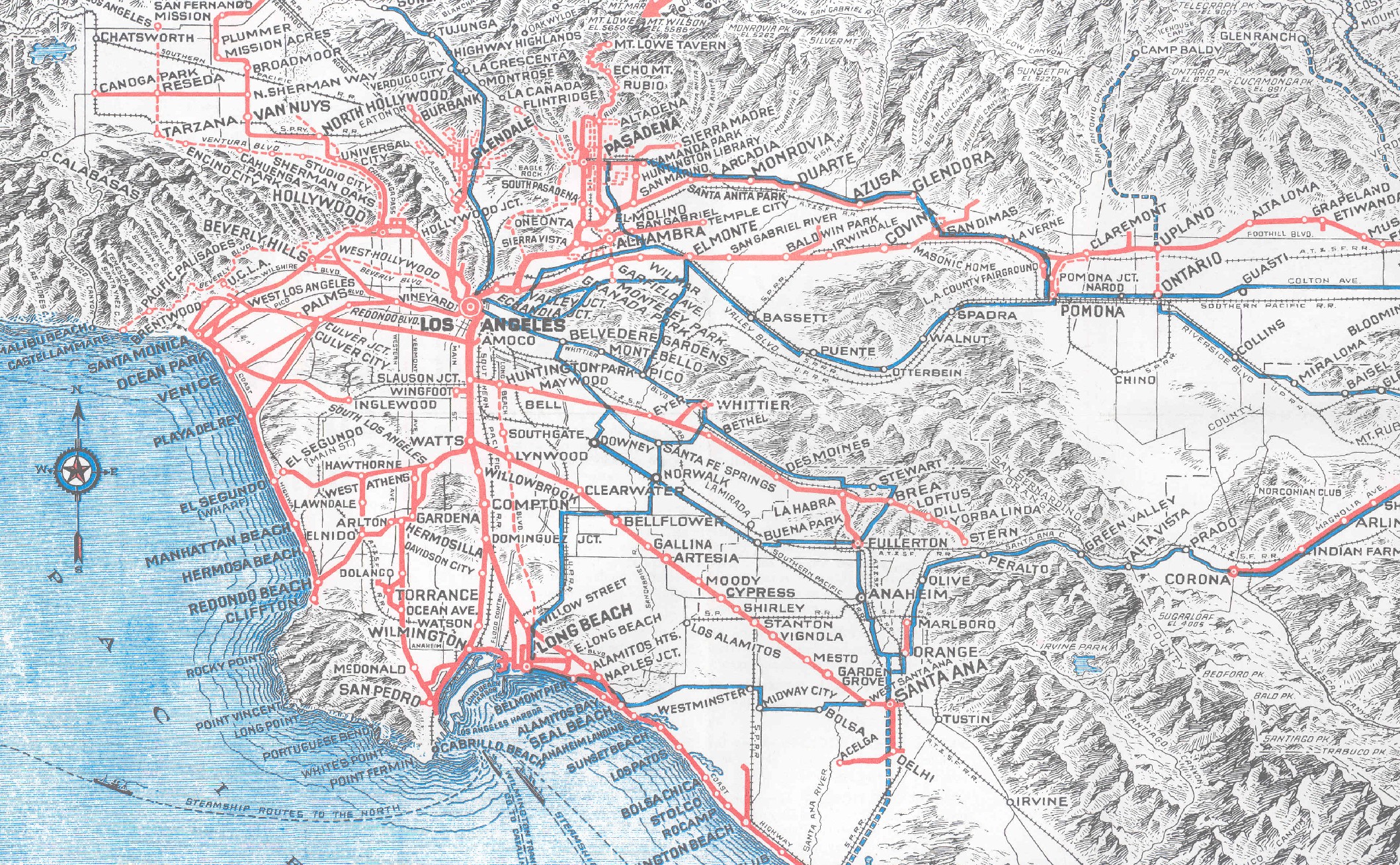
(Above: 1925 Pacific Electric Route Map, click to enlarge. These old maps are full of intriguing tidbits, like Sunset Boulevard being the original Beverly Boulevard - as noted here).
We had hoped to find the same maps featured in the book on the Los Angeles Public Library website. Unfortunately, the L.A. Unfolded exhibit is not listed on the LAPL Past Exhibits webpage, but some of their 100,000 maps can be found in their digital collection online.
 We, however, maintain an online map collection titled Past Visions Of L.A.'s Transportation Future: Mass Rapid Transit Concept Maps.
Here you will find an online gallery from 1925 to present-day, focusing on proposed rail and rapid transit plans over the years.
We are hoping to bring more map resources online as time permits.
(Above: 1925 Pacific Electric Route Map, click to enlarge. These old maps are full of intriguing tidbits, like Sunset Boulevard being the original Beverly Boulevard - as noted here).
Readers are also invited to explore our full-text digital collection of Los Angeles Transit And Transportation Studies, 1911-1957. These documents also include rare maps and other illustrative material from L.A.'s transit and transportation history.